Overview
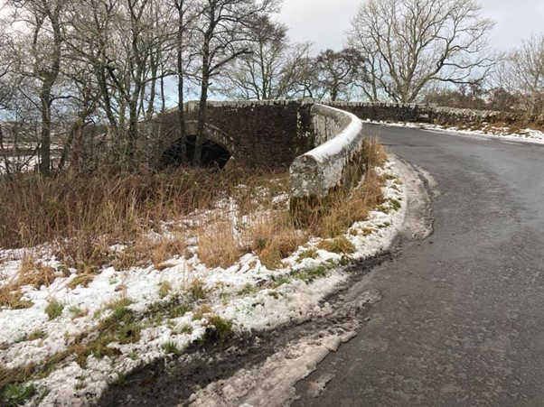
The Fell and Forest starts and finishes at the Chirdon Burn Bridge in Tarset nr Kielder taking in some of the finest forests and moorland of Northumberland.
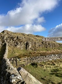
Along the way you will pass hidden gems of Northumberland such as Jerry’s Linn as well as world Heritage site of Hadrian’s Wall and Sycamore Gap. But mostly you will become very familiar with the endless variety and type of Northumberland mud.
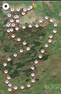
The route itself was researched, tweaked and tested over the course of a year until I was happy with it. The first few versions had a lot more open moorland with no defined paths which would make navigation tricky for those unfamiliar with the area. I replaced these sections with forestry tracks however, there are still parts of the final version which will mean you have to keep alert and on your toes navigation wise.
Date: 25 February 2021
Weather: Cloudy with sunny intervals – No rain – Temp between 6-10 degrees – Wind gusting up to 35mph.
I Wore:
- A pair of Higherstate 2in1 shorts
- A Nevica long sleeve wicking base layer
- Pair of lightweight woolen gloves
- Buff on my wrist for snot and hockle
- Decathlon running cap
- More Mile ankle trail socks
- Scott Kinabalu trail shoes
- I carried (never put it on) my OMM Kamleika coat which I’ve had for around 6 years
- Garmin 230 fully charged (lasts 14hours in smart mode)
Bags:
- Ultimate Direction AK Mountain 10L race vest
- Additional storage in an OMM 3.5L bumbag.
Kit:
- Head torch fully charged
- Full length emergency foil blanket
- Shit kit (toilet paper/wet wipes)
- Small tub of vasoline
- 2x paracetamol
- 6 pro-plus caffeine tablets
- Small power bank with iphone and watch charging cable
- iPhone
Food and water carried from start:
- 2 full 500ml flasks of water (1 with electrolyte tablet, 1 plain water)
- 2 spare empty 500ml soft flasks
- 1 tube of Trebor Softmints
- 3 SiS gels (I prefer real food these days)
- Small bite size pieces of cheese
- 2 Mars bars and 2 Snicker bars
- 2 egg/ mayo rolls
- 4 mini cheese and onion pies
- Tube of electrolyte tablets
Dropbag contents (24 miles)
- 2 litres of water
- Bag of wine gums
- 2 Snicker bars
- 2 Cheese and marmite rolls
- An orange
- Tube of trebor softmints
- Packet of salt and vinegar crisps
- 2 cheese and onion pasties.
I can never gauge how much food and water I’ll need on self-supported runs like this, so I always tend to go for more than I need. I carried 2 spare soft flasks which would give me capacity to carry 2 full litres. But on this occasion with decent conditions, I’d been getting through water at a rate of 500ml per 10 miles so I decided I would only take 3 x 500ml flasks for the remainder of the day.
- I ate the 2 cheese and onion pasties, orange and crisps as I stopped for 10 minutes at the drop bag. I drank about 250ml of water from the 2L bottle after filling 3x500ml flasks.
- I left the 2 snicker bars and soft mints because I didn’t need them.
I repacked my race vest and bumbag so the race vest had the heavier items and the bum bag lighter items. Then stashed the drop bag back in the undergrowth for collection the following day and set off again before my body temperature dropped.
Report:
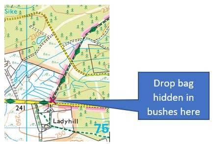
I had the week off work during the 3rd Covid lockdown in Feb 2021 and to break up the monotony I decided to run the latest tweaked version of the route to see if it needed refining further. Because there are absolutely no shops or facilities on the route I planted a drop bag the previous night in some bushes where the Pennine Way emerges onto Ward Lane (Falconry Days Bird of Prey centre) near Stonehaugh. This is approximately halfway distance wise.
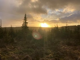
I set off at approximately 06:45 by touching the bridge and straight into the first short but steep climb of the day. It was quite windy but kept my coat packed away as I put some effort into the climb. I had a target in my head of about 5mph (12:30 minute miles) which would see me get around in 10 hours but conditions underfoot would be the ultimate make or break. That said, the first 6 miles or so of the route is on decent forestry tracks, with the hindrance of 1000ft of ascent. It was whilst climbing this forestry track that sun rose over the treeline so snapped a photo.
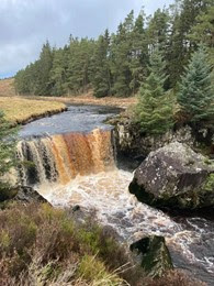
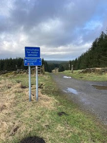
Leaving the forestry track after a couple of turns passing through the No military vehicles gate down to Allerybanks. I love this section of soft grass carpet through a clearing in the trees. I was making good time ticking over 6 miles in an hour, ahead of schedule. Leaving the forestry running along the side of Chirdon Burn towards the first obligatory photo stop at Jerry’s Linn. You can hear the waterfall before you see it, running high along a ridge of trees before descending towards the Linn.
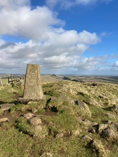
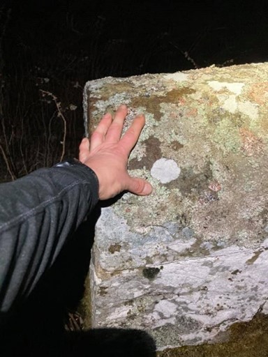
After leaving the Linn it’s a short run over some rough ground emerging onto the next forestry road. The forestry road is an opportunity to bank some time which may have been lost over the rough ground after the Linn. I dug in and pushed on towards where the route picks up a trail marker (which is very easily missed) leaving the forestry road just passed Irish Bridge. This next section is a twisty, soggy and muddy trail which steadily climbs for a couple of miles. It was here my feet got wet for the first time of the day and wet they would stay for the next several hours! Past the first trig point, easily missed on the right which is the second photo opportunity of the day. The trail emerges onto another forestry track in Pundershaw Forest, but a downhill forestry track so it was time to step up the pace and bank some more time. I settled into a decent pace, sub 8min/miles taking the turn onto some soft grassy forestry trails and some short but steep climbs.
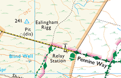
The route leaves Pundershaw forest and you have the first open moorland of the day to cross. Your feet may have dried out slightly on the forestry tracks, but they won’t stay dry for long. This is the start of the hard work. It’s also where you need to be on the ball with navigation as you need to ignore instinct and ignore obvious routes along quad bike tracks. There are a couple of way markers you need to totally ignore and head off in the opposite direction. So keep your GPX file open and watch out for going off course.
The main reference point is the TV mast. If you stray off course, head towards the TV mast as that’s where you pick up the Pennine Way.
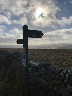
Eventually you will get to the top of Dunterley Fell and along the access road to the TV mast. The first Pennine Way marker post is along this road. There is also a slight detour you could take to the second Trig Point (adds about 3 or 4 minutes) of the route.
You now stay on the Pennine Way for 13 or so miles. As a national trail its well-marked route, but there are a couple of areas you will need to consult a map/GPS. This stretch is mainly through dry stone wall enclosed fields, open moorland, forestry and one section which goes through someone’s garden! It’s very varied, it’s also very muddy no matter what time of year you run it. For me, by the time I picked up the Pennine Way next to the TV mast I was nearly 30 minutes and three miles ahead of schedule with a downhill section across moorland stretching out in front of me for a couple of miles. However, it was above ankle muddy so impossible to move at any decent pace. My running slowed to a jog/slog. You don’t need me to tell you how utterly strength sapping running through endless mud and hills is, but I just have.

I have run this section countless times so knew what I had to do. It was a case of head down, plough on and ignore the voices telling you this is horrible. The wind had been a bit of a pain in the arse, gusting up to 35mph which was enough to block the sound from my headphones but not enough to stop me in my tracks.
My focus was the drop bag at mile 24ish, it had some goodies and a handwritten label by my daughter Amelia.

I stopped long enough to eat the 2 cheese and onion slices, fill 3x500ml soft flasks, re-adjust the weight around my pack and headed off before my body temperature dropped too much. I stashed the drop bag back in the bush and went back to collect the following day. I’d been steadily getting through my food carried from the start but didn’t need everything from the drop bag so left a few items.
I carried on slogging through the mud and picking the pace up where I could. Timewise I had slipped to 15 minutes behind schedule, but still feeling fresh I had it in mind I could pick the time up later in the day on forestry tracks. There is a balancing act between not expending too much energy on these muddy sections and saving enough for the very runnable last 14 miles.
The first sight of distant crags and Hadrian’s Wall appear when you emerge from Wark Forest to cross Haughton Common. A great photo opportunity and a moral boost.
Its more mud and bogs to cross before getting to Hadrians Wall, but you might start to see the odd walker, so make sure no-one sees you walking at least until you’re out of sight.
Eventually, you reach the stile over Hadrians Wall. Rest there, congratulate yourself for a minute or so, scrape the mud out your shoes eat something and look at the short but near vertical climb in front of you. The next 6ish miles you will climb and descent near enough 1000ft, but because there are people around there is the temptation to hammer it, showing off. Believe me, I do it every time. When you see someone huffing and puffing on all fours climbing up a section, you just have to zoom past them even though your legs are screaming.
If you’ve had enough and tapping out, you can be picked up from the Steel Rigg car park. There is also an ice cream van and coffee vendor here during summer months. But not in winter.
Stay on the Pennine Way/Hadrians Wall path climbing up to the trig point on Whinshield Crag.
Keep going up and down until leaving the Pennine Way and cutting across Melkridge Common. The stile is some stone steps built into the wall, make sure you don’t go through the gate.

By this point I was way behind my target time, but knew it wasn’t far until the most runnable part of the route starts. Just a couple more boggy and muddy fields to cross. This bit could be ticky for some navigation wise, but there are defined stiles and waymarkers as handrails. But studying the route and keeping an eye on GPS/Map you’ll not have any bother. Getting to the farm track after Wealside, if you’ve paced it well, you’ll be able to make some time up as thankfully, there is not more mud on the route. I on the other hand was wrecked, could barely manage 10 min miles, was about 45 mins behind schedule and doing that run to that tree, walk to that tree, run to that tree thing.
Navigation wise it’s easy from this point, it’s almost a straight run with barely any turns. Basically, you follow the national cycle trail 68. It is well sign posted and from Edges Green to Scotchcoultard a steady tarmac climb but runnable. At Scotchcoultard the tarmac ends and becomes a forestry trail.
At this point of the route I was tired, I was fed up, I was sore, but I was on the last stretch and most importantly no more mud! I took a couple of minutes to dig out my last cheese and marmite bap, a handful of wine gums, emptied the irritating stones from my shoes then ran. Well, I ran until I hit the next climb. But running the downhills, the flats and slight uphill’s is where I was hoping to make my time up. I had no idea how far behind pace I was, but 10 hours was out of reach.
The 68 national cycle route takes you all the way to East Whygate farm. It is here you have to be careful not to overshoot, like I did the first time.
The turning up the lane after East Whygate farm climbs steadily to Harelaw Crags, which I’d normally run up if I’d not already ran through miles of mud. In my head I was thinking of the route and realised there was only one more navigation turning point. So, I power hiked up, aided by necking 4 pro-plus at the bottom of the hill.
I love how caffeine tablets just suddenly kick in without you being aware. One minute you’re feeling grim, then suddenly, you’re humming a tune and powering up a hill smiling. Not that I’m an advocate of taking chemicals, but I always pack some sort of caffeine product on my runs.
The tarmac ends and becomes a forestry track, which you stay on for 4 or 5 miles. You may need to look at a map, but basically stay on the path. You pass the Bothy at “Green” on OS maps which isn’t far from Irish Bridge and the final stretch.
When I reached Irish Bridge, I seen my footprints from that morning in the mud heading in the opposite direction. Gave me a kind of boost, because this is my stamping ground, trails and routes I run most days. On reaching the crossroads at Allerybanks/Hog Holes it’s a final right turn and that’s the track to stay on all the way to the finish and home. The sun was starting to go down and the almost full moon was hanging in the sky, it wasn’t dark enough to pull out my headtorch and I set myself a new goal of getting home before needing it. I was running on familiar ground, I knew all the climbs and the downhills. I was counting off how far it was from this turning, how far it was from this cattle grid, how far it was from this farm gate. Getting closer. Unfortunately, I decided to get my head-torch out for safety reasons as a neighbour passed on his quadbike along the Chirdon Burn with his headlights on. It’s a single lane track with a dead end but a few farms use it. I passed the stack of silage bales past Dally Castle which meant it’s 1 mile to home and 0.5 miles to the end of the route at Chirdon Burn Bridge. One last climb, which I ran and over the bridge where I stopped my watch as I touched the stone.
I was done, I was happy, but I was way over my 10 hours target. It took me 11:37 but v3 of Fell and Forest was 3 miles further than v2 and I’d ran v3 20 minutes faster. It’s all stats but took some solace. I’m already planning my next attempt and where I can shave off at least 1.5 hours.

A great read, well done. I am planning currently my attempt!